
Surveying & Mapping Drones
We provide Lifetime support and repairs on any drones purchased through DC Geomatics
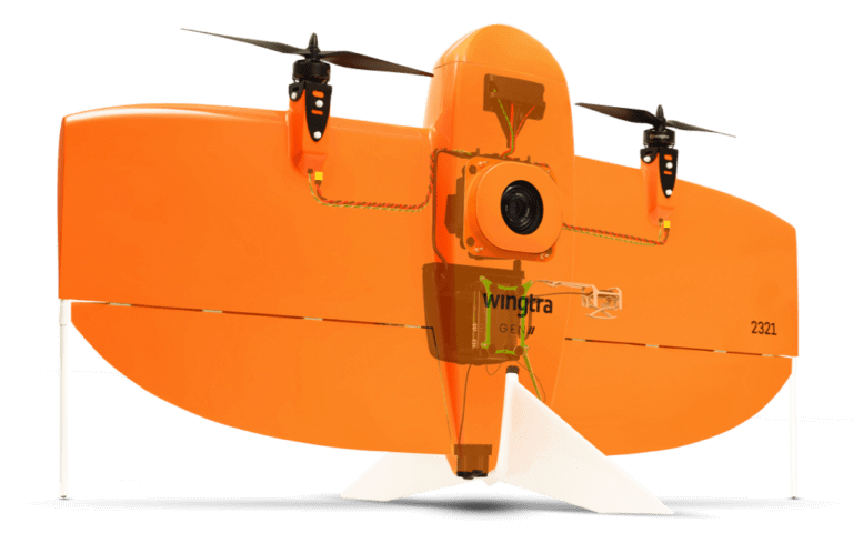
WINGTRA 1 GEN 2
WingtraOne GEN II’s unique set of features empowers you to minimize your time flying and get more work done, be it another project in the field or analyzing your data at the office, the forming body enables more effective spraying, especially for fruit trees. Using DJI digital agriculture solutions, the T30 helps reduce fertilizer use and increase yield with effective, data-driven best practices.
-

DJI Matrice 300
Experience the M300 RTK commercial drone for surveying, inspections, security, and agriculture.
-

Matrice 350 RTK
An upgraded flagship drone platform, the Matrice 350 RTK sets a new benchmark for the industry. This next-generation drone platform features an all-new video transmission system and control experience, a more efficient battery system, and more comprehensive safety features, as well as robust payload and expansion capabilities. It is fully powered to inject innovative strength into any aerial operation.
-

DJI Mavic 3 Enterprise
The Mavic 3 Enterprise Series redefines industry standards for small commercial drones. With a mechanical shutter, a 56× zoom camera, and an RTK module for centimetre-level precision, the Mavic 3E brings mapping and mission efficiency to new heights. A thermal version is available for firefighting, search and rescue, inspection, and night operations.
Interested in purchasing a drone for SURVEYING AND MAPPING?
We provide ongoing support and repairs on any drones purchased through DC Geomatics.